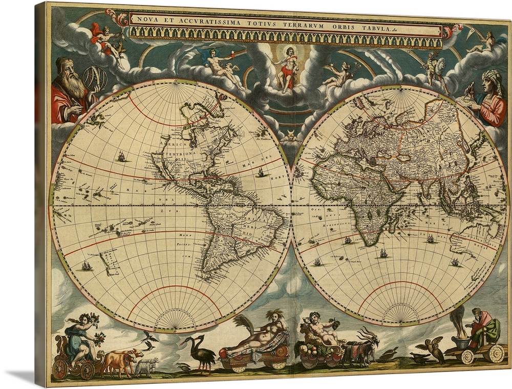
<p>World map, published around 1664 in Amsterdam, the Netherlands, by Dutch mapmaker Joan Blaeu (c.1599- 1673). The Latin title is Nova et Accuratissima Totius Terrarum Orbis Tabula (new and accurate all world map). Blaeu's maps built on those made by Mercator and Hondius in the late 16th and early 17th centuries. The Blaeu maps emphasized fine art and colours, being the most expensive of the time. Two mapmakers are shown at upper right and upper left, together with a wide variety of mythical beings. The poorly-mapped regions include the far north and south, parts of the Americas (left-hand hemisphere), and the Far East. The western coast of Australia (New Holland) was discovered in 1616.</p>


Elevate any room with our handcrafted stretched canvas gallery wraps. Printed with archival inks and wrapped around a 1.25” inch solid wood stretcher bar, our giclée big canvas art prints are a timeless option for any décor style or space.
<p>Our giclée canvas art prints are produced with high quality, UV-resistant, environmentally-friendly, latex inks and artist grade, polycotton canvas. We pride ourselves on color accuracy and image clarity to ensure your new canvas wall art lasts for years to come.</p>

<p>Assembled in the USA, each of our 1.25” inch gallery wrapped canvas art prints is stretched and stapled by our highly skilled craftspeople. Each canvas print is carefully handcrafted to ensure taut canvas wraps and clean corners for outstanding quality and durability.</p>

<p>Our handcrafted stretched canvas prints include sawtooth hangers for an easy and secure installation.</p>
 History
World History
Early Modern
Maps
Antique Maps
History
World History
Early Modern
Maps
Antique Maps