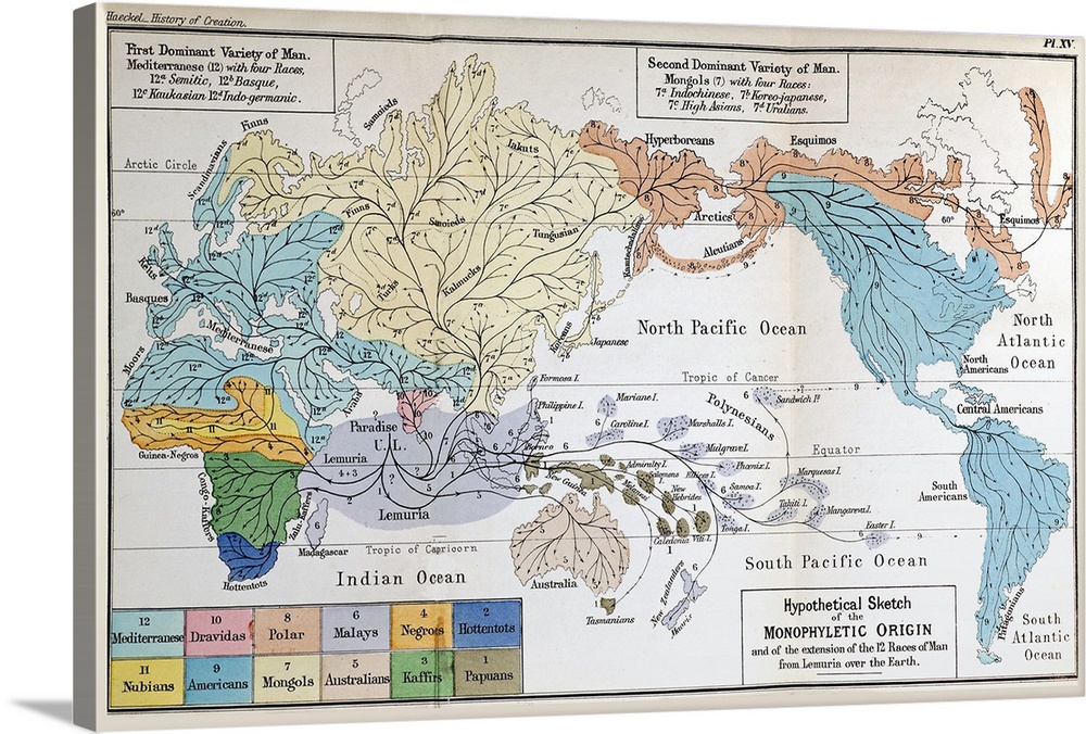
<p>Frontis plate with illustration from Ernst Haeckel \The History of Creation\ English translation by Prof. E. Ray Lankaster 1876. \A hypothetical sketch of the monophyletic origin and of the extension of the 12 races of man from Lemuria over the Earth\. While Darwin correctly suspected an African origin for mankind, Haeckel hypothesised a lost continent of Lemuria from which the various races of mankind had spread. Though there seemed little basis in geology for this supposition, it suited his own racial ideologies and would help him explain the (then) rarity of human fossils (on account of them being lost on a drowned continent). It also helped explain the anomalous distribution of Lemurs (hence the name) in the seemingly disconnected realms of Africa, Madagascar, India and Asia. We now have many early hominid fossils from Africa and explain lemur distributions with continental drift.</p>


Elevate any room with our handcrafted stretched canvas gallery wraps. Printed with archival inks and wrapped around a 1.25” inch solid wood stretcher bar, our giclée big canvas art prints are a timeless option for any decor style or space.
<p>Our giclée canvas art prints are produced with high quality, UV-resistant, environmentally-friendly, latex inks and artist grade, polycotton canvas. We pride ourselves on color accuracy and image clarity to ensure your new canvas wall art lasts for years to come.</p>

<p>Assembled in the USA, each of our 1.25” inch gallery wrapped canvas art prints is stretched and stapled by our highly skilled craftspeople. Each canvas print is carefully handcrafted to ensure taut canvas wraps and clean corners for outstanding quality and durability.</p>

<p>Our handcrafted stretched canvas prints include sawtooth hangers for an easy and secure installation.</p>
 Educational
History
Science
Prehistory
Illustrations
Maps
Antique Maps
Educational Maps
Paul Stewart
Educational
History
Science
Prehistory
Illustrations
Maps
Antique Maps
Educational Maps
Paul Stewart