<p>Detlev van Ravenswaay is a contemporary artist creating digital space-themed illustrations, diagrams, and infographics.</p>
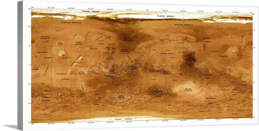
<p>Mars topographical map. Three-dimensional composite satellite image of the surface of Mars. Topographical features are labelled in black. North is at top. Features visible include the Chryse Planitia (just left of centre), a plain with a diameter of around 840 kilometres, and Olympus Mons (far centre left), the tallest known volcano and mountain in our solar system. The map was created using data from the Mars Global Surveyor spacecraft's Mars Orbiter Laser Altimeter.</p>


Elevate any room with our handcrafted stretched canvas gallery wraps. Printed with archival inks and wrapped around a 1.25” inch solid wood stretcher bar, our giclée big canvas art prints are a timeless option for any decor style or space.
<p>Our giclée canvas art prints are produced with high quality, UV-resistant, environmentally-friendly, latex inks and artist grade, polycotton canvas. We pride ourselves on color accuracy and image clarity to ensure your new canvas wall art lasts for years to come.</p>

<p>Assembled in the USA, each of our 1.25” inch gallery wrapped canvas art prints is stretched and stapled by our highly skilled craftspeople. Each canvas print is carefully handcrafted to ensure taut canvas wraps and clean corners for outstanding quality and durability.</p>

<p>Our handcrafted stretched canvas prints include sawtooth hangers for an easy and secure installation.</p>
 Educational
Science
Astronomy
Maps
Educational Maps
Space
Planets and Satellites
Detlev Van Ravenswaay
Educational
Science
Astronomy
Maps
Educational Maps
Space
Planets and Satellites
Detlev Van Ravenswaay