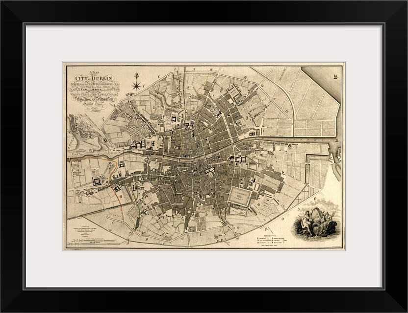
<p>Map of the City of Dublin, Ireland. Published in 1797, this map includes details of the canals being built at the time. Canal Harbour (lower right) connects across bottom with the Grand Canal (lower left). The Royal Canal (upper right and a branch at upper centre) was a competing canal. Running across centre is the River Liffey. Borders of the city's wards are marked in coloured lines, with a key at lower right, next to the city coat of arms. The scale at lower left is in both English and Irish miles. In 1797, Ireland was ruled by Britain, and this map was published by the geographer to King George III and the Prince of Wales (the future King George IV).</p>


Showcase your favorite artwork in a contemporary, handcrafted framed art print. These premium and timeless frames are sure to work with any decor or style of art. With multiple handcrafted frame styles to choose from, we’re confident you’ll find the perfect frame for your new fine art selection.
<p>Each piece of <a href="/category/all/?product=15&sort=age-asc">framed art is printed</a> with UV-resistant, archival latex inks to ensure color accuracy, image clarity, and long-lasting print quality. Our giclée art prints are reproduced in vivid detail on premium fine art paper for a high quality reproduction.</p>
<p>Our framed art prints come in a multitude of beautiful finishes. Each handcrafted wooden frame is available in a range of colors and finishes to pair with any art or decor style.</p>

<p>Each framed art print is printed and assembled by hand in the USA by our team of skilled craftspeople. Our framed prints include a classic single picture frame mat, a protective acrylic glazing, a finished dust cover back, and premium hanging hardware.</p>
<p>Start enjoying your framed art print sooner with our preinstalled hanging hardware. All framed prints include D-ring and wire hanger.</p>
 Educational
History
Maps
Antique Maps
Maps by City
Ireland
Dublin
Educational
History
Maps
Antique Maps
Maps by City
Ireland
Dublin