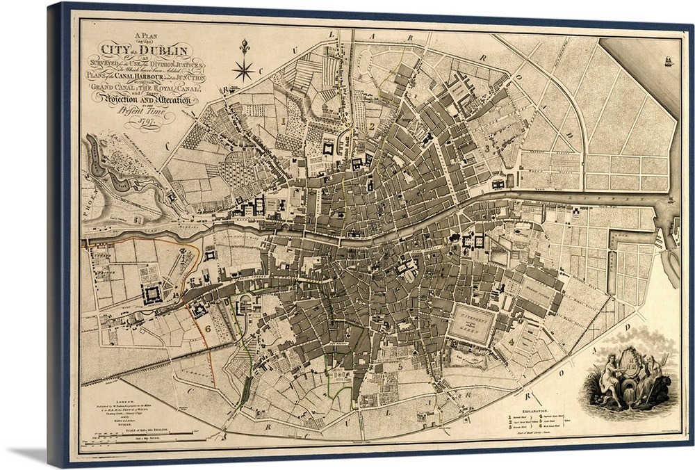
<p>Map of the City of Dublin, Ireland. Published in 1797, this map includes details of the canals being built at the time. Canal Harbour (lower right) connects across bottom with the Grand Canal (lower left). The Royal Canal (upper right and a branch at upper centre) was a competing canal. Running across centre is the River Liffey. Borders of the city's wards are marked in coloured lines, with a key at lower right, next to the city coat of arms. The scale at lower left is in both English and Irish miles. In 1797, Ireland was ruled by Britain, and this map was published by the geographer to King George III and the Prince of Wales (the future King George IV).</p>


Elevate any room with our handcrafted stretched canvas gallery wraps. Printed with archival inks and wrapped around a 1.25” inch solid wood stretcher bar, our giclée big canvas art prints are a timeless option for any decor style or space.
<p>Our giclée canvas art prints are produced with high quality, UV-resistant, environmentally-friendly, latex inks and artist grade, polycotton canvas. We pride ourselves on color accuracy and image clarity to ensure your new canvas wall art lasts for years to come.</p>

<p>Assembled in the USA, each of our 1.25” inch gallery wrapped canvas art prints is stretched and stapled by our highly skilled craftspeople. Each canvas print is carefully handcrafted to ensure taut canvas wraps and clean corners for outstanding quality and durability.</p>

<p>Our handcrafted stretched canvas prints include sawtooth hangers for an easy and secure installation.</p>
 Educational
History
Maps
Antique Maps
Maps by City
Ireland
Dublin
Educational
History
Maps
Antique Maps
Maps by City
Ireland
Dublin