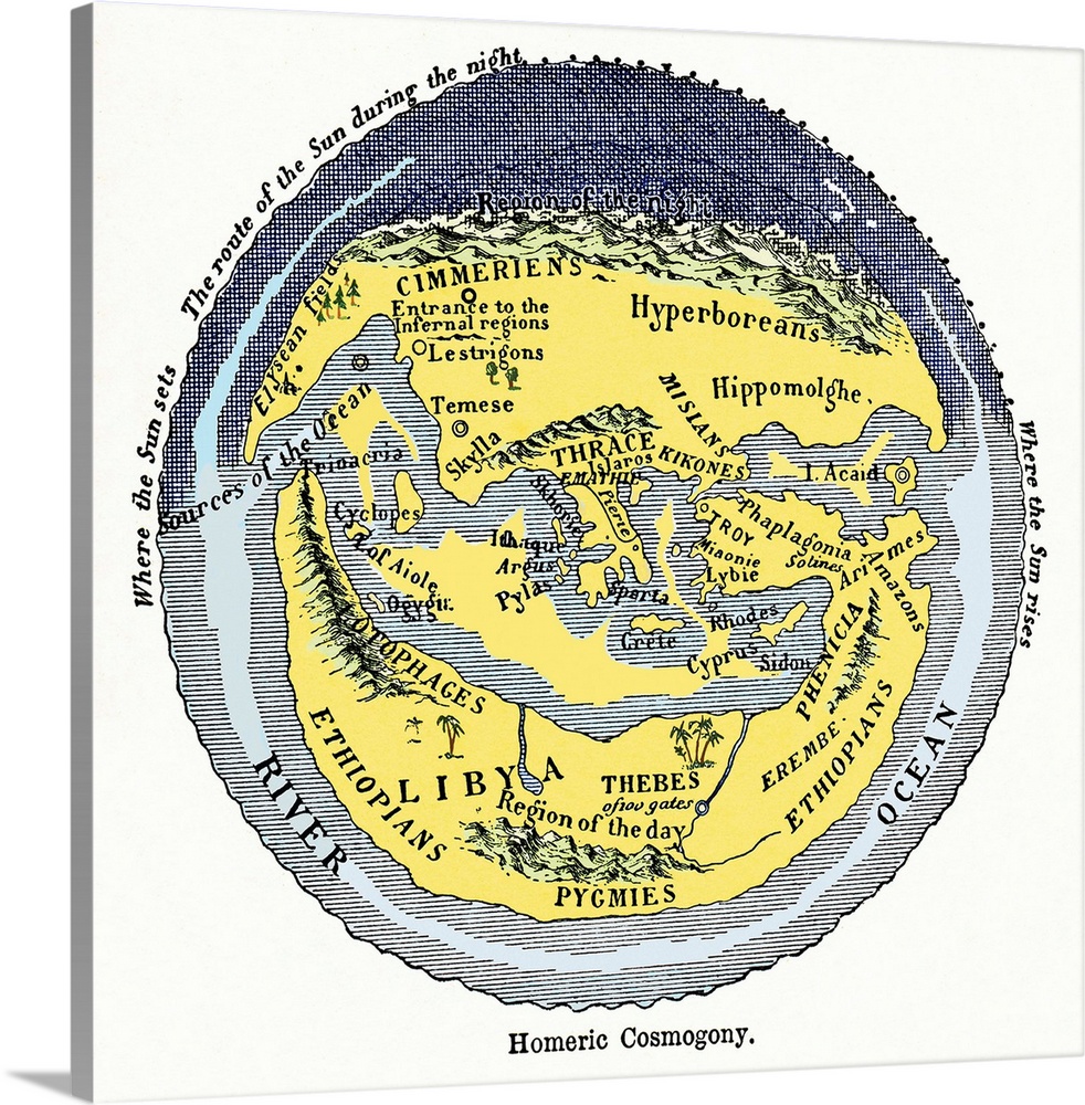
<p>Homeric cosmogony. Map of the Earth based on the myths and knowledge of the Ancient Greeks at the time of Homer (1st or 2nd millennium BC). The map shows a flat Earth centred on Greece and the Mediterranean Sea, surrounded by a 'River Ocean'. At night, the Sun passes from west to east behind a range of high mountains in the north ('region of the night'). To the south in North Africa, is the 'region of the day'. Other mythological references include the Elysian Fields, the island of the Cyclops, and the entrance to hell. Civilisations (historical and mythological) marked here include: Ethiopians, Libyans, Pygmies, Egyptians, Amazons, Phoenicians, Hyperboreans and Cimmerians. Places include: Thebes, Sparta, Troy, Thrace, Crete and Cyprus. Artwork from Pioneers of Science (Oliver Lodge, 1893).</p>


Elevate any room with our handcrafted stretched canvas gallery wraps. Printed with archival inks and wrapped around a 1.25” inch solid wood stretcher bar, our giclée big canvas art prints are a timeless option for any decor style or space.
<p>Our giclée canvas art prints are produced with high quality, UV-resistant, environmentally-friendly, latex inks and artist grade, polycotton canvas. We pride ourselves on color accuracy and image clarity to ensure your new canvas wall art lasts for years to come.</p>

<p>Assembled in the USA, each of our 1.25” inch gallery wrapped canvas art prints is stretched and stapled by our highly skilled craftspeople. Each canvas print is carefully handcrafted to ensure taut canvas wraps and clean corners for outstanding quality and durability.</p>

<p>Our handcrafted stretched canvas prints include sawtooth hangers for an easy and secure installation.</p>
 Maps
Educational
History
Ancient
Science
Earth Science
Maps
Sheila Terry
Maps
Educational
History
Ancient
Science
Earth Science
Maps
Sheila Terry