<p>Detlev van Ravenswaay is a contemporary artist creating digital space-themed illustrations, diagrams, and infographics.</p>
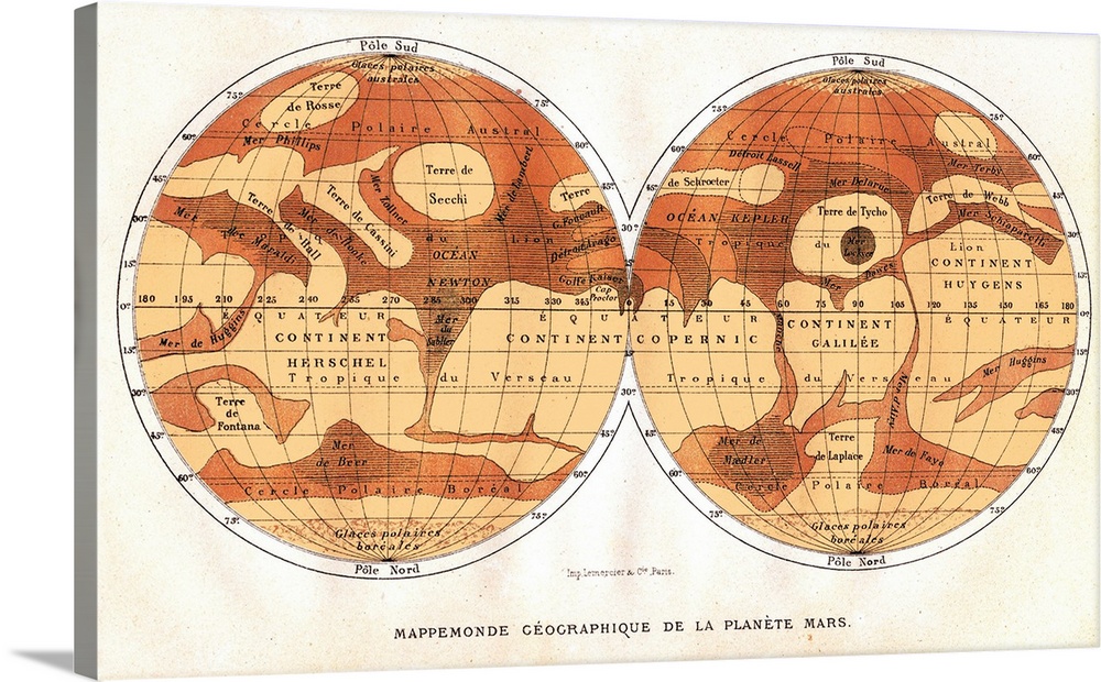
<p>Map of Mars, published in Paris in 1881. The first accurate telescope observations of Mars were made in 1877 and 1881 when Mars was at its closest to Earth (a situation called an opposition). The map (north at bottom) does show the dark and light areas thought to be seas and continents, but now known to be highlands (dark) and lowlands (light). The map features are named for famous astronomers. The Mer Sciaparelli (upper right) is now known as Valles Marineris, and Terre de Secchi (upper left) is an impact basin now named Hellas Planitia.</p>


Elevate any room with our handcrafted stretched canvas gallery wraps. Printed with archival inks and wrapped around a 1.25” inch solid wood stretcher bar, our giclée big canvas art prints are a timeless option for any décor style or space.
<p>Our giclée canvas art prints are produced with high quality, UV-resistant, environmentally-friendly, latex inks and artist grade, polycotton canvas. We pride ourselves on color accuracy and image clarity to ensure your new canvas wall art lasts for years to come.</p>

<p>Assembled in the USA, each of our 1.25” inch gallery wrapped canvas art prints is stretched and stapled by our highly skilled craftspeople. Each canvas print is carefully handcrafted to ensure taut canvas wraps and clean corners for outstanding quality and durability.</p>

<p>Our handcrafted stretched canvas prints include sawtooth hangers for an easy and secure installation.</p>
 Science
Astronomy
Illustrations
Maps
Antique Maps
Space
Planets and Satellites
Detlev Van Ravenswaay
Science
Astronomy
Illustrations
Maps
Antique Maps
Space
Planets and Satellites
Detlev Van Ravenswaay