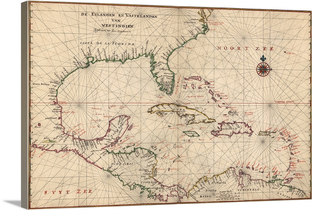
<p>Navigational chart that shows the coasts of North America and South America from Virginia through the Yucatan Peninsula in Mexico to Guiana in South America, with Cuba, the island of Hispaniola and the West Indies.</p>


Elevate any room with our handcrafted stretched canvas gallery wraps. Printed with archival inks and wrapped around a 1.25” inch solid wood stretcher bar, our giclée big canvas art prints are a timeless option for any décor style or space.
<p>Our giclée canvas art prints are produced with high quality, UV-resistant, environmentally-friendly, latex inks and artist grade, polycotton canvas. We pride ourselves on color accuracy and image clarity to ensure your new canvas wall art lasts for years to come.</p>

<p>Assembled in the USA, each of our 1.25” inch gallery wrapped canvas art prints is stretched and stapled by our highly skilled craftspeople. Each canvas print is carefully handcrafted to ensure taut canvas wraps and clean corners for outstanding quality and durability.</p>

<p>Our handcrafted stretched canvas prints include sawtooth hangers for an easy and secure installation.</p>
 Maps
Antique Maps
Caribbean
Bahamas
Barbados
Bermuda
Cayman Islands
Cuba
Dominican Republic
Jamaica
Saint Vincent and the Grenadines
Costa Rica
El Salvador
Honduras
Maps
Antique Maps
Caribbean
Bahamas
Barbados
Bermuda
Cayman Islands
Cuba
Dominican Republic
Jamaica
Saint Vincent and the Grenadines
Costa Rica
El Salvador
Honduras